Boat Bay, Coolibah/Kwila Streets & Helipad on Tully Mission Beach Road
|
Helipad on Tully Mission Beach Road
Here is a copy of the final judgment by His Honour Judge Morzone QC on C4's appeal against the decision on the Material Change of Use for Air Services at 2244 Tully-Mission beach Road (Lot 3). The Appeal was allowed in part and the development is subject to 22 conditions. |
| ||
Coolibah & Kwila Street clearing
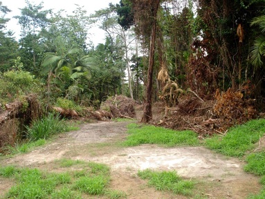 View looking eastward from Coolibah street to Kwila street. Drain is on the left.
C4’s response to CLEARING between COOLIBAH and KWILA streets WONGALING
The area adjacent to the drain is zoned Conservation Precinct and was virgin forest prior to the CCRC pushing the East-West track. The site is probably the best example of Mesophyll vine forest on beach ridges and sand plains of beach origin at Mission Beach. It is an excellent example of littoral rainforest in an accessible public protected area. Being 100% RE 7.2.1, it equates wholly with the critically endangered ecological community listed under EPBC as Littoral Rainforest & Coastal Vine Thickets of Eastern Australia. Fieldwork has confirmed this.
The Littoral Rainforest Listing Advice, Conservation Advice and EPBC Policy Statement identify 5 threats to littoral rainforest: Clearing, disturbance and modification; inappropriately placed paths/tracks including beach access and amenities; Invasive weeds; inappropriate fire regimes; and Trampling, browsing and grazing by feral animals and livestock. The recent activity increased the first 3 of these 5 threats.
The subject site is already in a small patch with lots of edges and surrounding weeds. Removal of vegetation including ground cover, use of heavy machinery, and pushing cleared material into remnant areas makes small patch such as this even smaller and increases edges and the likelihood of transformer weed invasion and decline of the ecological community.
The site is also essential cassowary habitat.
C4’s response to CCRC explanation
It is incumbent on CCRC to use appropriate machinery and provide appropriate instruction and supervision of operations in such an important ecological area.
Cleared debris should not be pushed into the Conservation Precinct as this severely reduces and degrades the area.
The CSC had for 30 odd years managed to traverse the private property and mats and/or a smaller cheaper machine could have been used to avoid lawn damage. An alternate East-West approach is available and councils leave easements for this purpose.
The entire area has been left in a state which is prone to erosion (the wet is approaching) since all the top soil has been removed and the surface left very rough.
Environmentally this has been a needlessly destructive exercise and the action and response shows a disregard for a community which cares for the beauty of the area and a Tourism organization that is planning to base their future on nature based tourism.
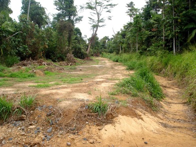 The cleared vegetation running parallel to Coolibah Street, Wongaling Beach.
Council’s response to vegetation clearing works conducted at Coolibah and Kwila steets.
Myself and Cr Bryce Macdonald raised community concerns we perceived over clearing of access to drains at Wongaling Beach. Council has investigated the concerns, please find following councils response.
In response to a number of concerns raised by the community and Councillors regarding the vegetation clearing works conducted in and adjacent to the open drains between Coolibah Street and Kwila Street, Wongaling Beach, please be advised as follows: -
· These drains are part of council's infrastructure and require regular cleaning to prevent flooding of property and houses during significant rain events, as occurred in 2006-07.
· The open drains were constructed to service the developed area and are part of council's responsibility to manage and to do this access is required for appropriate machinery.
· The drains where this work has occurred are on council owned free hold land.
· The drains were cleaned for the first time in a considerable period following a major rain event in 2006-07 that resulted in flooding through houses and property. The supervisor in charge at the time received permission from the relevant senior council staff to clean the drains and accesses to remove debris and to reinstate the capacity within the drain. I understand there was considerable debris from Cyclone Larry left in the drains.
· Drain cleaning has been carried out on an annual basis ever since to mitigate flooding. It should be noted that no flooding has occurred since cleaning operations recommenced in 2006-07, including the major rain depression that followed Cyclone Yasi.
· Works undertaken recently were for the cleaning of the access track adjacent to the east-west drain from Coolibah Street to the main north-south drain that discharges to Porters Creek. This work involved removal of fallen trees, dead vegetation and small re-growth vegetation from the track and pushing it back to the existing tree line. I understand that this access has not been cleaned since at least Cyclone Yasi and most likely well before that. This work also involved pushing of sand and roots to the existing tree line to allow access for large machinery.
· Access is required for a 20 tonne excavator as this is the size of excavator required to both clean the main north-south drain north of the junction and to cross the main drain (excavator lifts itself across the drain).
· The east-west drain was cleaned by way of removing vegetation (mostly fallen trees) only using a grab bucket. This was done to minimise the disturbance to the existing bed and thereby minimising sediment displacement.
· Erosion control measures (silt fencing) have been installed where deemed necessary.
· The access track along the main north-south drain to Porters Creek forms part of the major flow path with the deeper drain section catering for low flow situations (i.e. most normal rainfall events).
· The east-west access track cleaning was required as the alternative accesses used in recent years were no longer available as they traversed private property.
· The cleared areas will be allowed to revegetate along the edge of the track to the tree line and the track will be kept clear by slashing on a regular basis.
· In some areas the cleaning appears to be wider than necessary, however, the cleaning was done to allow machinery access and the debris and sand pushed back to the existing tree line. The existing tree line does not follow the alignment of the drain perfectly giving the appearance of being wider than necessary in parts.
Cheers
Cr Alister Pike Cassowary Coast Regional Council
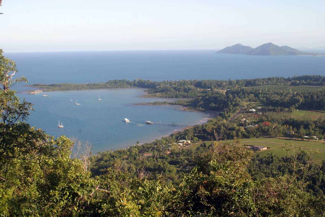
Boat Bay
C4 Position Statement
C4 recognizes the community need for improved boat launching facilities at Mission Beach.
We support a concept that fulfils these community needs, with no adverse impact on the environment and opportunity to improve
cultural and environmental assets of Clump Point and Boat Bay to benefit current and future generations.
Five Outcomes
1. Support improvement to the launching facilities at Mission Beach which have no adverse impact on the environmental and cultural values of Clump Point and reflects community needs.
Specific improvements:
- Increased access to boat ramps (addition of another ramp?)
- Increased parking spaces
- Improved low-environmental impact lighting
- Reinstatement of boat ramps existing prior to cyclone Larry
2. Sealing of the existing road to the ramp and the lookout to minimise the erosion into Boat Bay and dust on the vegetation.
3. Rehabilitation and improvement to the unique Clump Point environment.
4. An interpretive walk to link Ulysses with the Cutten Brother’s walk.
5. Strategic informative environmental signage for Clump Point.
C4 RESPONSE TO AURECON PROPOSAL 22 NOVEMBER 2013
Delivered Friday 29th November 2013
Community for Coastal and Cassowary Conservation (C4) commends the Government and Aurecon for the detailed assessment of the options for improved maritime facilities at Mission Beach.
We appreciate that both DSDIP and Aurecon have given assurance that modelling would be used to test and establish that optimum outcome would be achieved in terms of wave mitigation and minimal silt build-up.
Overall, we support the proposals with the following comments:
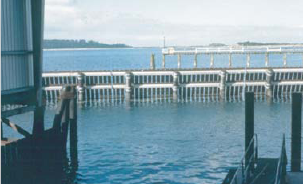
Boat Ramp.
This is basically the designed proposed by C4. See Low Impact Boat Ramp concept file at end of this page.The third boat ramp has a larger footprint than proposed and the Northern car park takes out more mangroves then envisaged. An offset is proposed but a loss is a loss. However mangroves could be encouraged to grow on the new rocks.
The southern car park appears to be located as C4 proposed and CCRC surveyed. This doesn’t seem to appear in any of the drawings but was shown on screen on the day.
Jetty rock wall
C4 remains committed to the improvements to the boat ramp and additions to make the jetty functional with little or no adverse visual or environmental impact and supports the separation of commercial and recreational facilities. We appreciate the assurance that modelling is an integral part of the process to ensure the optimal outcomes in terms of protection while having least impact on the bay and neighbouring beaches.
C4 has been asked by members and others to request that DSDIP and Arecon consider options other then the rock wave breakwater since it is seen as expensive, has high visual impact and poses a high risk of siltation.
Aurecon’s multi-criteria analysis (22 November 2013) states that the components it considered were to “improve the safety of boating facilities in the region”, that facilities in Boat Bay “need to be improved to meet current and future needs, and to address safety concerns associated with the lack of wave attenuation at the jetty”.
C4 has had time to read and discuss the full documents and can no longer support the construction of the wave breakwater. It was alarming to note in Appendix C table 13 KPI results that Theme 14 Overtopping breakwater was rated Intermediate (likely to form partial tombolo?) There have been no rock wall breakwaters placed anywhere in the Great Barrier Reef Marine Park to date. This proposed breakwater would be a precedent. No island rock wall, artificial reef or other stand-alone structure has ever been permitted in the Great Barrier Reef World Heritage Area (GBRWHA), which was listed for its outstanding natural and aesthetic qualities, with an obligation to protect its integrity as a naturally beautiful place. Mission Beach is a tourist destination and tourists expect natural tropical beauty.
Aurecon’s conclusion that the wave breakwater is the best solution is not backed by wind climate or current and sediment drift studies. There are limited details of all options provided in Aurecon’s analysis, making informed comparisons quite difficult. Modelling in a tank as proposed by Aurecon in the recent media release does not appear to address the particular conditions that exist along this dynamic and exposed coastline. All potential options should be modelled and wind and current studies undertaken in the Clump Point/boat bay area
The following option is offered, with a request that it be seriously considered.
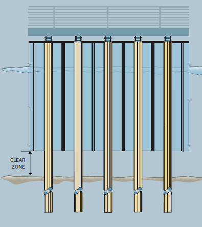
Construction of a vertical ventrally open wall (aka partial penetrating wave barrier) away from the jetty, as built in many marinas and harbours along the coast. Advantages include:
Road access to the boat ramp
The current dirt road is a major contributor to siltation in the bay. C4 has had discussions with CCRC. It is understood that DSDIP and CCRC are continuing with discussions with a view to resolving the problem.
Existing eastern boat ramp
It is unclear if any walkway or tie-off rail has been included which would allow this ramp to become operational.
Condition and height of car park and turn-around
At high tide (3M) the area is inundated and the sea comes in through the rocks under the concrete and bubbles up through the asphalt. The vehicles parked on the Northern end are splashed with waves. It is unclear if this is rectified in Improved drainage (5). With this in mind the southern car park option may be a dryer alternative and its construction does not harm any mangroves.
Dredging of the eastern boat ramp
During modelling it would be interesting to know if modifications to the location of the existing breakwater could alleviate dredging and this knowledge be used during the breakwater upgrade(20)
Other boat ramps
The peak demand for boat access is at times of good weather and particularly mackerel season. Off-the-beach launching for "tinnies", as was previously available at CCRC caravan park, took a lot of pressure off Clump Point ramp at these times. Beach ladders at environmentally suitable points is a preferred option for many people with tinnies, particularly as Dunk Island is about four times as far from Clump Point as it is from South Mission Beach and this issue should not be overlooked in the overall boating picture.
Delivered Friday 29th November 2013
Community for Coastal and Cassowary Conservation (C4) commends the Government and Aurecon for the detailed assessment of the options for improved maritime facilities at Mission Beach.
We appreciate that both DSDIP and Aurecon have given assurance that modelling would be used to test and establish that optimum outcome would be achieved in terms of wave mitigation and minimal silt build-up.
Overall, we support the proposals with the following comments:
Boat Ramp.
This is basically the designed proposed by C4. See Low Impact Boat Ramp concept file at end of this page.The third boat ramp has a larger footprint than proposed and the Northern car park takes out more mangroves then envisaged. An offset is proposed but a loss is a loss. However mangroves could be encouraged to grow on the new rocks.
The southern car park appears to be located as C4 proposed and CCRC surveyed. This doesn’t seem to appear in any of the drawings but was shown on screen on the day.
Jetty rock wall
C4 remains committed to the improvements to the boat ramp and additions to make the jetty functional with little or no adverse visual or environmental impact and supports the separation of commercial and recreational facilities. We appreciate the assurance that modelling is an integral part of the process to ensure the optimal outcomes in terms of protection while having least impact on the bay and neighbouring beaches.
C4 has been asked by members and others to request that DSDIP and Arecon consider options other then the rock wave breakwater since it is seen as expensive, has high visual impact and poses a high risk of siltation.
Aurecon’s multi-criteria analysis (22 November 2013) states that the components it considered were to “improve the safety of boating facilities in the region”, that facilities in Boat Bay “need to be improved to meet current and future needs, and to address safety concerns associated with the lack of wave attenuation at the jetty”.
C4 has had time to read and discuss the full documents and can no longer support the construction of the wave breakwater. It was alarming to note in Appendix C table 13 KPI results that Theme 14 Overtopping breakwater was rated Intermediate (likely to form partial tombolo?) There have been no rock wall breakwaters placed anywhere in the Great Barrier Reef Marine Park to date. This proposed breakwater would be a precedent. No island rock wall, artificial reef or other stand-alone structure has ever been permitted in the Great Barrier Reef World Heritage Area (GBRWHA), which was listed for its outstanding natural and aesthetic qualities, with an obligation to protect its integrity as a naturally beautiful place. Mission Beach is a tourist destination and tourists expect natural tropical beauty.
Aurecon’s conclusion that the wave breakwater is the best solution is not backed by wind climate or current and sediment drift studies. There are limited details of all options provided in Aurecon’s analysis, making informed comparisons quite difficult. Modelling in a tank as proposed by Aurecon in the recent media release does not appear to address the particular conditions that exist along this dynamic and exposed coastline. All potential options should be modelled and wind and current studies undertaken in the Clump Point/boat bay area
The following option is offered, with a request that it be seriously considered.
Construction of a vertical ventrally open wall (aka partial penetrating wave barrier) away from the jetty, as built in many marinas and harbours along the coast. Advantages include:
- Allows unrestricted water flow under the wall, thus avoiding sediment accumulation
- Minimises marine environmental impact.
- Minimises footprint
- Effective at lower tides when needed most
- Easy to see for navigation
- Less visually intrusive than a large rock breakwater
- No reflected waves as with a skirt wall
- Can be removed for modifications and repair
- Some chance of acceptance by GBRMPA - images of partial penetrating wave barrier at end of this report
Road access to the boat ramp
The current dirt road is a major contributor to siltation in the bay. C4 has had discussions with CCRC. It is understood that DSDIP and CCRC are continuing with discussions with a view to resolving the problem.
Existing eastern boat ramp
It is unclear if any walkway or tie-off rail has been included which would allow this ramp to become operational.
Condition and height of car park and turn-around
At high tide (3M) the area is inundated and the sea comes in through the rocks under the concrete and bubbles up through the asphalt. The vehicles parked on the Northern end are splashed with waves. It is unclear if this is rectified in Improved drainage (5). With this in mind the southern car park option may be a dryer alternative and its construction does not harm any mangroves.
Dredging of the eastern boat ramp
During modelling it would be interesting to know if modifications to the location of the existing breakwater could alleviate dredging and this knowledge be used during the breakwater upgrade(20)
Other boat ramps
The peak demand for boat access is at times of good weather and particularly mackerel season. Off-the-beach launching for "tinnies", as was previously available at CCRC caravan park, took a lot of pressure off Clump Point ramp at these times. Beach ladders at environmentally suitable points is a preferred option for many people with tinnies, particularly as Dunk Island is about four times as far from Clump Point as it is from South Mission Beach and this issue should not be overlooked in the overall boating picture.
| Aurecon 2013 Clump Point Report on Options multi-criteria analysis.pdf |
| C4 response to MB boat bay infrastructure options workshop.pdf |
| Workshop report 13 Feb 2013.pdf |
Mission Beach Safe Boating Infrastructure Options Workshop Report and C4's Response
A copy of the above report and the response from C4 can be downloaded from the file's above.